|
Highlights:
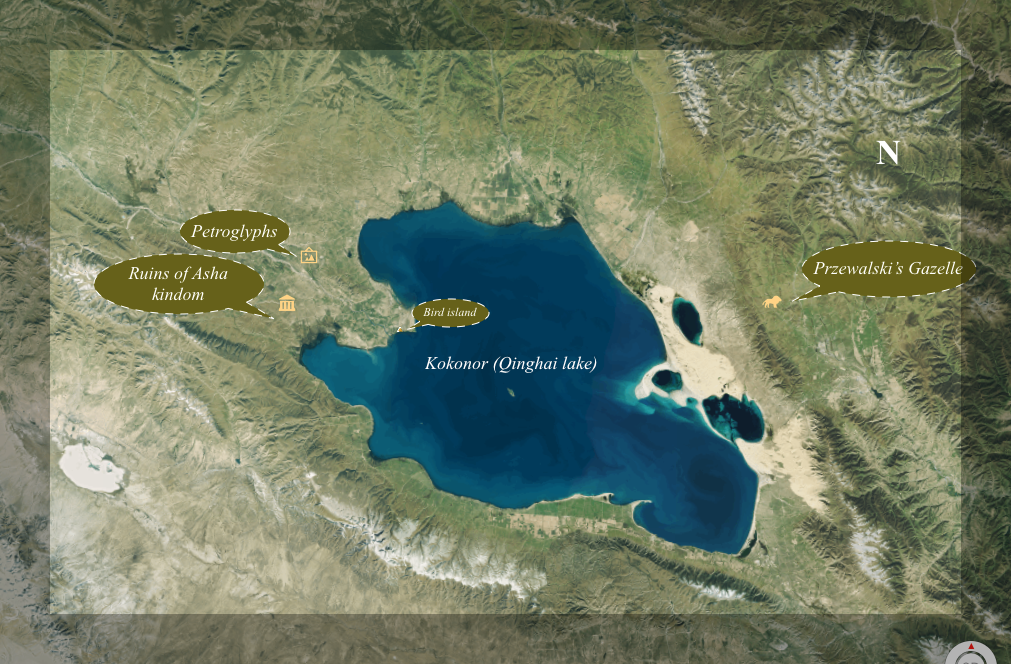
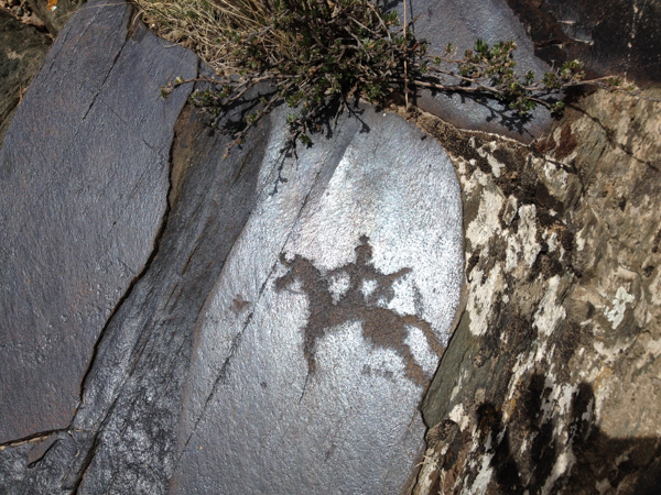
Kokonor or Qinghai lake is not just simply a lake for native Tibetans living around. The cultural and historic findings, such as petroglyphs, the ruins of the Asha (Tuyuhuang) Kingdom, monasteries, hermitage, the bird's island, duns on the north side of the lake, rare animals, legends, folk tells customs and the spirits around the lake make it more sacred and worth visiting.
|
|
Overview:
Regione: Amdo (Qinghai provience)
Trip Length: 3-4 days
Starts: from Xining
Ends: in Xining
Best season: June- July– Aug-early Sept.
Road trip:
|
Lake Kokonor: (Mongolian: Хөх нуур)(Qinghai Lake) (Chinese: 青海湖), or Tsongon Po(Tibetan: མཚོ་སྔོན་པོ།) is the second largest lake in Asia. Located in Qinghai province on an endorheic basin, Kokonor Lake is classified as a saline andalkaline lake. It has a surface area of 4,317 square km; an average depth of 21m, and a maximum depth of 25.5m as measured in 2008.[2] The current Chinese name is "Qinghai," the older Mongolian name is Kokonor, and the Tibetan name is "Trishor Gyalmo" (meaning 10,000 people lost their lives as they submerged according to the local legend), respectively. The Lake is located about 160 kilometers west of the provincial capital of Xining (Tib:Ziling ཟི་ལིང་།) at 3,205 m (10,515 feet) above sea level in a depression of the Tibetan plateau.[3] Twenty-three rivers and streams empty into Qinghai Lake, most of them seasonal. Five permanent streams provide 80% of the total influx.[4] The lake has fluctuated in size, shrinking over much of the 20th century, but has increased since 2004. Despite its salinity, it has an abundance of fish, such as the edible naked carp (Gymnocypris przewalskii, huángyú .
 Geography
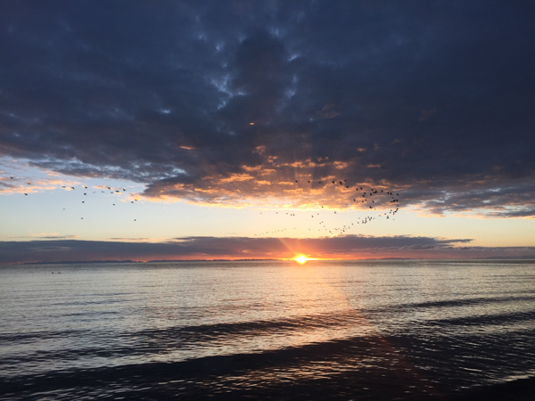
Qinghai Lake is sandwiched between Hainan and Haibei Tibetan Autonomous Prefectures in northeastern Qinghai. The lake is located at the crossroads of several bird migration routes across Asia. Many species use Qinghai as an intermediate stop during migration. At the tip of the peninsula on the western side of the lake are the "Bird Islands" (Cormorant Island and Egg Island), which have been bird sanctuaries of the Qinghai Lake Natural Protection Zone since 1997. The lake often remains frozen for three months continuously in winter. There is an island in the western part of the lake with a temple and a few hermitages called "Mahādeva, the Heart of the Lake" (mTsho snying Ma hā de wa) which historically was home to a Buddhist monastery.No boat was used during summer, so monks and pilgrims traveled to and fro only when the lake froze over in winter. A nomad described the size of the island by saying that: "if in the morning a she-goat starts to browse the grass around it clockwise and its kid anti-clockwise, they will meet only in the night, which shows how big the island is. It is also known as the place where Gushri Khan and other Khoshut Mongols migrated during the 1620s. The lake is circumambulated by pilgrims, mainly Tibetan Buddhists, especially every Horse Year of the 12-year cycle. Przhevalsky estimated it would take about 8 days by horse or 15 walking to circumambulate the lake, but pilgrims report it takes about 18 days on horseback, and one took 23 days walking to complete the circuit

Przewalski's gazelle is perhaps one of the most endangered species of large mammals on Earth. There are many threats against the species, including competition with domestic livestock, and fencing of the natural habitat. These problems have become exacerbated as the area is increasingly developed as agricultural land.
While now protected by Chinese law, and illegal hunting no longer is considered an important factor, a large percentage of the habitat of this species has already been lost due to human activities. Consequently, it is considered to be an endangered species by the IUCN. Formerly, it was believed that as few as 250 remained, and it was considered critically endangered. However, this is now known to be an underestimate, with new sub-populations having been discovered in 2003 and 2006, and there are now believed to be 350-400 (and possibly even more) mature individuals left.
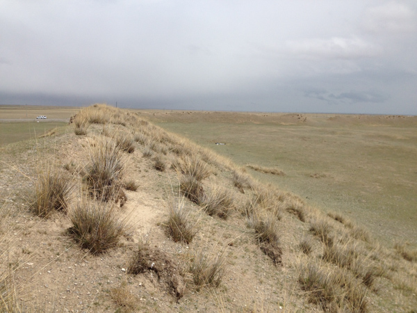
The ruins of the Asha/Tuyuhun kingdom and its History
After the disintegration of the Xianbei state, nomadic groups were led by their khagan, Tuyuhun, to the rich pasture lands around Kokonor Lake (Qinghai Lake) in the middle of the 3rd century.
Murong Tuyuhun was the older brother of
the Former Yan's ancestor Murong Hui and elder son of the Chanyu Murong Shegui of the Murong Xianbei who took his people from their original settlements on the Liaodong Peninsula to the region of the Yin Mountains, crossing the Yellow River between 307 and 313, and into the eastern region of modern Qinghai.
The Tuyuhun Empire was established in 284 by subjugating the native peoples referred to as the Qiang, including more than 100 different and loosely coordinated tribes that did not submit to each other or any authority.
After Tuyuhun died in Linxia, Gansu in 317, his sixty sons further expanded the empire by defeating the Western Qin (385-430) and Xia (407-431) kingdoms. The Qinghai Xianbei, Tufa Xianbei, Qifu Xianbei, and Haolian Xianbei joined them. They moved their capital 6 kilometers (3.7 mi) west of Qinghai Lake.
After Jin elevated their status by conferring on their ruler the old Xiongnu title of Chanyu in 281, they were ruled, from 285, by Murong Hui for five decades. These Xianbei groups formed the core of the Tuyuhun Empire and numbered about 3.3 million at their peak. They carried out extensive military expeditions westward, reaching as far as Hotan in Xinjiang and the borders of Kashmir and Afghanistan, and established a vast empire that encompassed Qinghai, Gansu, Ningxia, northern Sichuan, eastern Shaanxi, southern Xinjiang, and most of Tibet, stretching 1,500 kilometers from east to west and 1,000 kilometers from north to south. They unified parts of Inner Asia for the first time in history, developed the southern route of the Silk Road, and promoted cultural exchange between the eastern and western territories, dominating the northwest for more than three and half centuries until it was destroyed by the Tibetan Empire. The Tuyuhun Empire existed as an independent kingdom outside China and was not included as part of Chinese historiography.
The conflict between the Tang and Tibetan empire
At the beginning of the Tang dynasty, the Tuyuhun Empire came to a gradual decline and was increasingly caught in the conflict between China and Tibet. Because the Tuyuhun controlled the crucial trade routes between the east and the west, the empire became the immediate target of invasion by the Tang.
The Tibetan Empire developed rapidly under the leadership of Songtsen Gampo, who united the Tibetans and expanded northward, directly threatening the Tuyuhun Empire. Soon after he took the throne of the Yarlung Kingdom in Central Tibet in 634, he defeated the Tuyuhun near Qinghai Lake and received an envoy from the Tang. The Tibetan emperor requested marriage to a Chinese princess but was refused. In 635-6 the Tang emperor defeated the Tibetan army; after this campaign, the Chinese emperor agreed to provide a Chinese princess to Songtsen Gampo.
The Tibetan emperor, who claimed that the Tuyuhun objected to his marriage with the Tang, sent 200,000 troops to attack. The Tuyuhun troops retreated to Qinghai, whereas the Tibetans went eastward to attack the Tangut people and reached into southern Gansu. The Tang government sent troops to fight. Although the Tibetans withdrew in response, the Tuyuhun Empire lost much of its territory in southern Gansu to Tibetans.
The Tuyuhun Government was split between the pro-Tang and pro-Tibet fractions, with the latter increasingly becoming stronger and collaborating with Tibet to bring about an invasion. The Tang sent general Xue Rengui to lead 100,000 troops to fight Tibet in Dafeichuan (present Chab Cha [tib] (Gonghe County) [Ch], Qinghai). They were annihilated by the ambush of 200,000 troops led by Dayan and the Tibetans. Tibet overtook the entire territory of the Tuyuhun.
Disintegration
After the fall of the kingdom, the Tuyuhun people split. Led by Murong Nuohebo on the eastern side of the Qilian Mountains they migrated eastward into central China. The rest remained and were ruled by the Tibetan Empire.
Through this period, the Xianbei underwent massive diasporas over a vast territory that stretched from the northwest into central and eastern parts of China, with the greatest concentrations by Mt. Yin near Ordos Loop. In 946, a Shatuo, Liu Zhiyuan, conspired to murder the highest Xianbei leader, Bai Chengfu, who was reportedly so wealthy that “his horses had silver mangers”. With the looted wealth that included an abundance of property and thousands of fine horses, Liu established the Later Han (Five Dynasties) (947-950), which lasted only four years and became the shortest dynasty in Chinese history. The incident took away the central leadership and stripped the opportunity for the Xianbei to restore the Tuyuhun Kingdom, although later they were able to establish the Western Xia (1038-1227), which was destroyed by the Mongols.
Culture
The Tuyuhun people were experts in horse breeding and also practiced agriculture. As a realm just between the Chinese empires in the east (Northern Wei, and the Southern Dynasties) and other steppe tribes such as the Rouran Khaganateand the Tiele people, the Tuyuhun acted as envoys and traders, while many Buddhist missionaries and travelers crossed their country.
When the Chinese pilgrim monk, Songyun, visited the region in 518, he noted that the people had a written language, which was more than a hundred years before Thonmi Sambhota is said to have returned from India after developing a script for writing the Tibetan language.
Itinerary
What's included in the price
Map
Itinerary
Day01. arrival in Xining and transfer to Hotel.
Day02. Drive to Koknor lake and visit the Gonpa and the ruins of the Asha kingdom.
Day03. Visit the Przewalski's gazelle and return to Xining.
Day04. Departure
- Private professional English-speaking tour guide.
- Private vehicle and Luggage Transfers.
- Admission fees.
- Service Charge (the planning, handling, operational, and communication charges) & government taxes
What's excluded from this price?
- China visa, all air tickets.train tickets.
- Sightseeing is not listed in the itinerary..
- Gratuities, tips to guides, drivers, bellboys, etc {/xtypo_list}
Kokonor, Asha kingdoms, petroglyphs, and wild animals