Amdo Tibet
Destination: Tibet > Amdo
Information
The frontier land of Amdo (North-east Tibet) is a relatively low-lying region of spacious rolling pastures, where successive waves of ethnic migration have left their mark. Amdowa 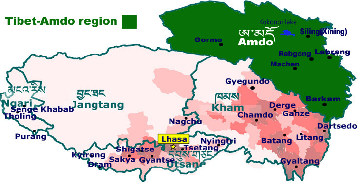 Tibetans, Mongols and Tu, Moslems (Hui, Salar, and Kazakh), and Han Chinese all have their own enclaves and spheres of influence. Amdo extends from the Kunlun Mountains in the west to the fabled Lake Kokonor, through the meandering upper reaches of the Yellow River and its tributaries, east to the upper reaches of the Min and Jialing rivers, and south, through Golok, to the upper reaches of the Gyarong (Sertal, Dzamtang, Ngawa, Chuchen and Rongtrak). The sixty counties of Amdo and Gyarong are currently divided between the provinces of Qinghai, Sichuan and Gansu.
Access
There are airports at Ziling (Ch. Xining), and Dzitsa Degu (Ch. Jiuzhaigou), as well as at the gateway cities of Lanzhou and Chengdu. The railway runs from Lanzhou through Ziling to Kermu and on to Lhasa, while most areas are linked through the road network: H109 passing through the Tsong-chu valley and Kokonor region to Kermu and the Kunluns, H227 through Serkhok, Mongyon and Chilen to Dunhuang, H214 through Chabcha, Tsogortang and Mato, and H213 through Lanzhou, Labrang, Luchu, Dzoge, Mewa and Zungchu to Chengdu.
Culture
The rich grazing pastures of Amdo sustain a high nomadic population in the Banak and Golok areas, where the sacred Mt Amnye Machen is the focal point for pilgrimage. Further north are the cultural centres of Rebkong, home to a distinctly vibrant tradition of Tibetan painting and clay sculpture, the hermitages of Achung Namdzong, contained with the Khamra National Park, and the monastic cities of Labrang and Kumbum Jampaling, To the south of Golok and west of Mt Nyenpo Yurtse, Amdo's second sacred range, are the major Nyingmapa monasteries of Tartang, Dodrubchen, Nyenlung and Larung Gar, and the Jonangpa enclaves of Dzamtang and Ngawa. The pre-Buddhist Bon tradition is strongest in Ngawa, in Gyarong - particularly in Chuchen and Rongtrak counties, nearby the sacred Bon mountain of Gyelmo Murdo, and further south in the national parks of Dzita Degu and Sertso, which until recently claimed the only five star hotels on the Tibetan plateau.
Kham Tibet
Tibet >Kham
Information
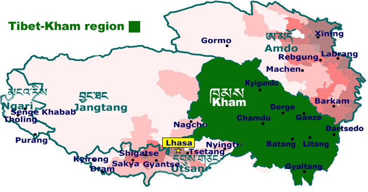 Far eastern Tibet (Kham) is the most densely populated region of the plateau - its inhabitants are distinguished from other Tibetans not only by their robust physical appearance, colorful dress and braided coiffure but by distinctive dialects and social customs. The terrain is characterized by extremely rugged and glaciated snow mountains, ranging from northwest to southeast, broken by rich grassland pastures and deep forested gorges formed by the Salween, Mekong, Yangtze, and their numerous tributaries. The region's forty-seven counties are divided for political and historical reasons between four provinces, twenty-five of them in the Chamdo, Nakchu, and Nyangtri prefectures of the Tibet Autonomous Region, three in the Dechen Autonomous Prefecture of Yunnan, seventeen in the Kandze and Mili autonomous areas of Sichuan, and six in the Jyekundo Autonomous Prefecture of Qinghai.
Access
There are several airports in Kham now. The first is in Ponda near Chamdo, the second is in Ganze near Dartsedo and the third one is in Yushu, Qinghai province. Most of the areas are accessible from Lhasa or the gateway cities (Chengdu, Kunming, and Xining) on national highways: H109 passes through Nakchu, H 317 through Chamdo, Derge, Kandze and Dartsedo, H318 through Po-me, Markham, Batang and Litang, and H214 through Jyekundo, Nangchen, Chamdo, and Dechen.
Culture
The monasteries of Kham, far removed from the political cauldron of Lhasa, are fast rebuilding and extending their influence as far as the neo-Buddhist communities of mainland China. Among them, the Nyingmapa are strongest in Derge, Pelyul and Nyarong, the Kagyupa in Nangchen, Derge and Derong, the Sakyapa in Derge and Jyekundo, and the Gelukpa in Chamdo, Litang, Batang and the south. The pre-Buddhist Bon tradition still has a significant presence in the Khyungpo region of the upper Salween. basin.
Kham is a region where the pageantry of Buddhist and secular festivals is renowned. Sacred masked dances performed in the context of the Drubchen ceremony are frequently held, exemplified by those at Katok commemorating the birth of Padmasambhava. Horse festivals, including officially sponsored events at Jyekundo and Litang, are occasions for the song, dance, and sporting contests, at which boisterous Khampa crowds proudly display their local costume and traditions.
It is no exaggeration to say that each county has its unique focal points for pilgrimage - foremost among them being Kyadrak Senge Dzong in Dzachuka, Gawalung in Po-me, Mt Kawa Karpo in Dechen, Nabun Dzong in Nangchen, Yegyel Namka Dzong in Riwoche, Chakdu Khawa Lungring in Nyarong, Mt Zhara Lhatse in Minyak, Rudam Gangi Rawa at Dzogchen, Pema Shelphuk in Mesho, Tsandra Rinchen Drak at Pelpung, Katok Dorjeden near Pelyul, and Khampo Nenang near Litang.
Utsang Tibet
Destination: Tibet>Utsang
Information
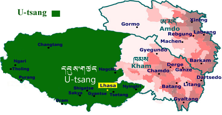 Utsang, the cultural heartland of Tibet, occupying the upper reaches of the Brahmaputra River, and its sheltered lateral valleys, is home to traditional agricultural communities, medieval monasteries of historic importance, and several modern towns and cities: Lhasa, capital of Tibet, stands on the Kyichu, Gyantse and Shigatse are on the Nyang-chu, Tsetang on the Yarlung-chu, and Bayi on the Gyamda Nyang-chu. The highland ( lato ) region to the southwest of Utsang is divided from Nepal by the Great Himalayan barrier range, which includes Mt Everest, the world's highest peak.
Access
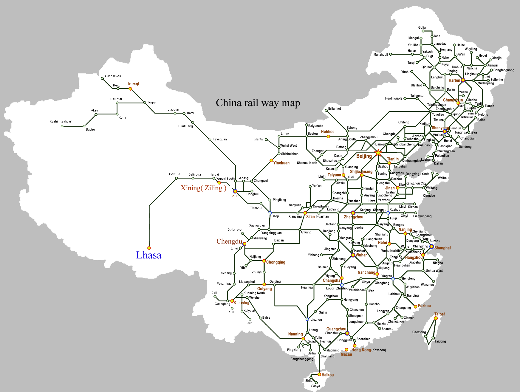
The only airports are at Gongkar which has international flights to Kathmandu and domestic flights to several Chinese cities; Bayi in Kongpo, which is serviced by domestic flights to and from Chengdu, and the newly opened airport at Shigatse. They are direct trains from major cities; Xining, Lanzhou, Beijing, Shanghai, and Chengdu but the most favorable train is from Xining. See the railway Map
Culture
Utsang's prestige derives from the great cultural sites associated with the ancient Tibetan monarchy: Yumbu Lagang-- the oldest castle, Tradruk-- the oldest Buddhist temple, Samye-the oldest Buddhist monastery, Chongye - the burial ground of the kings, and Jokhang & Ramoche-the original royal temples of Lhasa.
All the main traditions of Tibetan Buddhism established their mother monasteries here during medieval times: the Nyingmapa at Mindroling and Dorje Drak, the Kagyupa at Tsurphu, Drigung, Taklung and Ralung, the Sakyapa at Sakya and Ngor, and the Gelukpa at Ganden, Sera, Drepung, and Tashilhunpo. Even the Bon tradition established its principal centers at Yungdrungling and Menri in Tsang and at Bonri in Kongpo.
Lhasa's skyline is dominated by the Potala Palace, a UNESCO world heritage site, which is the winter residence of the successive Dalai Lamas.
Sacred and secular festivals are held throughout the year, according to the Tibetan lunar calendar. One of the most popular events is the Zhodun "yogurt" festival, held at Lhasa during the summer when performances of Tibetan opera are staged in the gardens of Norbulingka, the summer palace of the Dalai Lamas.
For trekkers, there are excellent trails in Utsang-from Dingri to Everest Base Camp, from Ganden to Samye, Tsurphu to Yangpachen, in the vicinity of Mt Namchak Barwa, and through the low-lying subtropical forested zone of Pemako.
Destination: Tibet >Ngari
Information
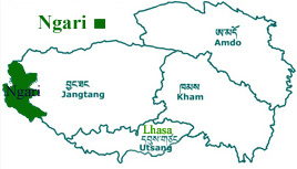 The region of far-west Tibet (Ngari), and the neighboring Jangtang plateau, are the least populated parts of the country. Mount Kailash, renowned for its spiritual magnetism and natural beauty, is the sacred focal point for pilgrims and hardy travelers. Concealed within the deeply eroded sandstone canyons of the upper Sutlej basin are numerous ruins of ancient troglodyte cities: Toling, Tsaparang, Dungkar, Piyang, and Manam, that once comprised the medieval kingdom of Gu-ge. A number of temples are still intact, containing exquisite murals and decorative motifs, some dating back more than 1,000 years.
Access
Ngari Gunsa Airport, near the prefectural capital of Senge Khabab, opened to the public in 2010. There are twice-weekly flights between Gongkar and Ngari Gunsa airports—weather permitting. Otherwise, access to this vast region is only possible through long overland drives from Lhasa, Nepal or Xinjiang (H219), or by helicopter from Nepalganj in Western Nepal. The Hindustan Highway from India which leads directly to Gu-ge is currently closed, pending resolution of a long-standing border dispute.
Culture
The northern plateau of Tibet, known as the Jangtang, is a vast Lakeland wilderness, over 438,000 sq km in area (average elevation: 4,500m), and demarcated by the Kunlun Mountains to the north, the Gangtise and Nyenchen Tanglha range to the south, the basin of the upper Indus to the west, and those of the upper Salween and Yangtze to the east and northeast. The Jangtang is dotted with brackish salt lakes, the largest among them being Namtso, Serling, Dangra Yutso, Ngangla Ringmo, and Pang-gang. In antiquity, the Jangtang was an important region for the pre-Buddhist civilization of Zhangzhung. Since 1993, its northernmost parts have formed the world's second-largest nature reserve (300,000 square kilometers), exceeded only by the ice-caps of the Greenland National Park. This is the natural habitat of the wild yak, kyang, blue sheep, argali, gazelle, and antelope, and predators, such as the wolf, lynx, brown bear, and the endangered snow leopard.